Krasnoyarsk Territory occupies most of the territory of Eastern Siberia. In total, 60 natural monuments of regional significance are registered on the territory of the region. Many of them, such as the Permafrost Museum, are known all over the world and have no analogues. The territories of natural monuments are reserved and protected by the state. This protects them from vandalism and destruction, and helps to increase their recreational value.
Natural monuments of the region have different types. These are geological ones - Minin Pillars or Guard Cave. Water - the Shush river or Oyskoe lake. Unique forests - Anashensky Bor, Lugavsky Bor. They all have different accessibility to tourists. For example, a spring on the Uzhurka River is located almost at the Federal Highway, and it is easier to fly to the geographic center of the Russian Federation in a couple of hours by helicopter.
Natural monuments of the Krasnoyarsk Territory
Karaulnaya cave
Located on the banks of the Yenisei, five km from the settlement of Udachny. There is a tourist recreation center nearby. The lowest point is at a depth of 41 meters from the entrance. The length of the cave is 540 meters. The cave is of natural origin, formed as a result of the slow destruction of rocks. The first tier of the cave is occupied by the Ice grotto. It contains a manhole to a gallery with beautiful calcite coverings. There is an underground lake in the Kapelny grotto.

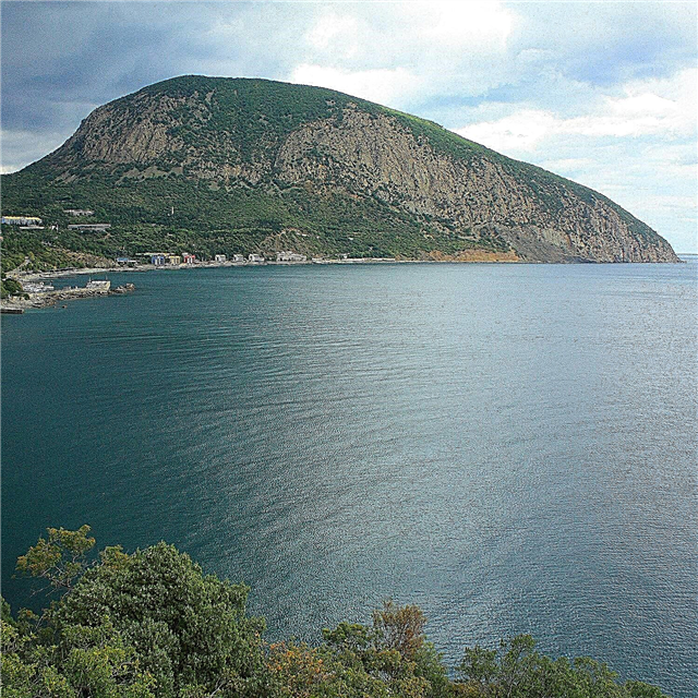
Black Sopka
An extinct volcano with a height of 688 meters in the Berezovsky district. This is almost a line of the city, from the top you can clearly see the city itself, as well as the Yenisei and the Stolby reserve. The slopes of the hill are covered with dense forest. The foot can be reached by car, then the path is laid up. It is quite difficult to walk along it, so tourists should evaluate their physical fitness before going up. They say that unusual energy is felt at the top of the hill.

Don't miss: 45 main attractions of Krasnoyarsk.
Ob-Yenisei connecting waterway
The shipping canal, founded at the end of the 19th century. It connects not the Ob and Yenisei, but small rivers from their basins. They are called Ket and Kas, therefore another name for the waterway is known as the Ket-Kass Canal. This unique hydraulic engineering facility is one of the largest engineering and architectural structures in Russia. The channel is currently used by tourists for educational purposes, especially among fans of ethno-tourism.

Minin pillars
Natural complex on the banks of the Yenisei. This natural monument of the Krasnoyarsk Territory is represented by monolithic rocks up to 30 meters high in a dense forest. A panoramic view of the Krasnoyarsk hydroelectric power station and the city of Divnogorsk opens from the tops of the ridges. Ecotourism is widespread on the Minin pillars. In summer, not only hikers come here, but also fans of cycling or quad biking.

Big nut cave
The largest conglomerate in the world. The length of the underground passages in it is 47 km. Since the passages have a labyrinthine structure, going deep into the cave is recommended only with experienced guides. In the grottoes of the cave there is an underground lake 15 meters deep, corners with stalagmites and stalactites. The air temperature in the cave is about +4 ° C and is constant at any time of the year.

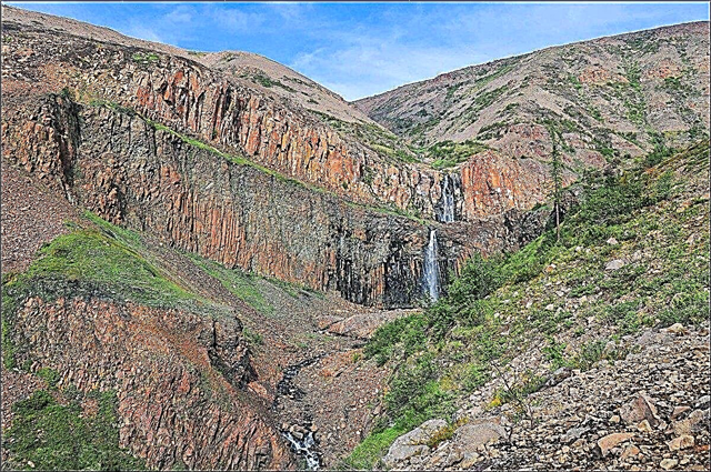
Kinzelyuk waterfall
The 400-meter high waterfall is called the pearl of the Central Sayan Mountains. Due to its location in the highlands, it is difficult to get there on your own. It is easier to do this as part of an organized excursion group, choosing a path by water in the middle of summer. The waterfall is unique in its shape. Despite its great height, it does not form cascades and thresholds and falls down in a wide, uniform stream. The views of the taiga around the waterfall are incredibly picturesque.

Geographical center of the Russian Federation
Located on the shores of Lake Vivi in the Evenk Autonomous Okrug. This is a point that is equidistant from all borders of the state. Its coordinates were approved in 1992 by the Federal Service of Geodesy and Cartography of Russia. A symbolic obelisk "The Golden Flower of Russia" and a small chapel of St. Sergius of Radonezh are installed in this place. Getting to this place on your own is extremely difficult.

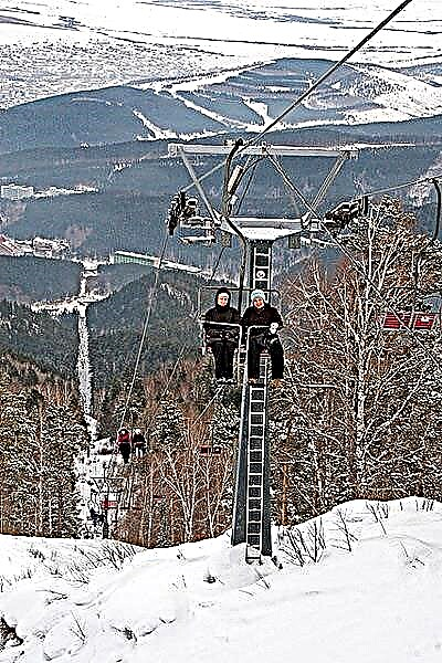
Lake Oyskoe
Many hiking trails have been laid near Lake Oyskoye, which is a regional natural monument. Tourists are attracted by its purest water and protected nature around. The depth of the lake reaches 25 meters. The forest around is mainly composed of fir and cedar. The lake is located on a ridge at an altitude of 1416 meters above sea level. Therefore, even on its southern shores there is snow in summer.

It is interesting: 30 most beautiful lakes of the Krasnoyarsk Territory.
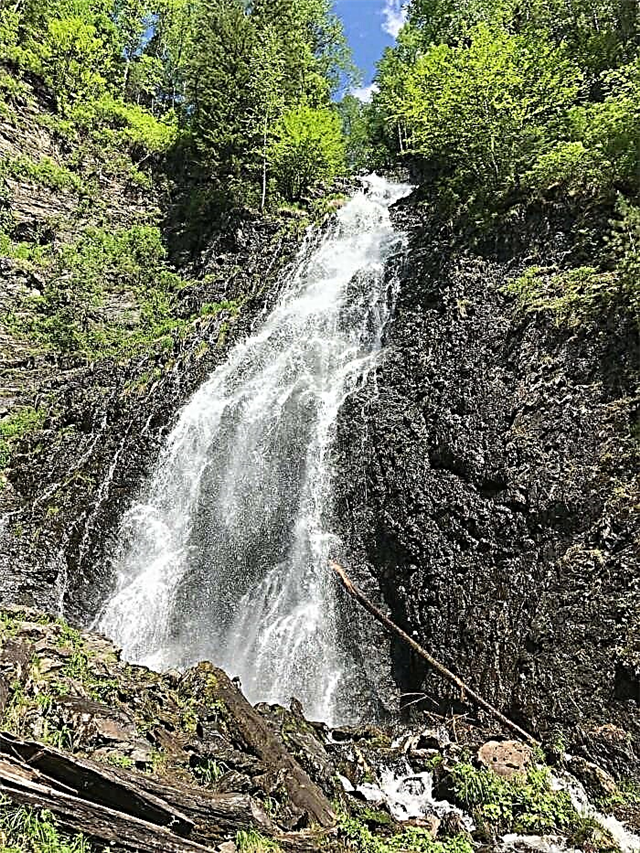
Chinzhebsky waterfall
The height of the two-stage waterfall is 30 meters, the width reaches 8 meters. The bottom is rocky, without a bowl, the water is cold. The maximum spillway reaches in June. The waterfall has the status of a natural monument, so a visit to the waterfall is allowed only with an instructor. However, locals and numerous tourists often disregard this prohibition. Many from the waterfall go higher into the mountains to the summit with the name Moscow.
Baja cave
It is a natural monument in the Eastern Sayan Mountains. The length of the cave is 6 km, the depth reaches 170 meters. The entrance is a funnel with a diameter of about 10 meters and a depth of about 20 meters. In the extended network of passages there is a lake, as well as two streams - Small and Porcelain. Bats are found in the cave. Visiting the cave is only allowed with permission from the security organization.

Permafrost Museum
Local history complex, located in the city of Igarka. Founded in 1965. The only one in the world that owns a dungeon deep in permafrost. The corridors and halls of the museum are at a depth of 14 meters. Among the exhibits there are blocks of ice 50,000 years old, larch in ice 36,000 years old. To preserve unique objects, the museum maintains a temperature of minus 5-6 ° C.

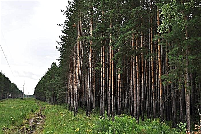
Anashensky Bor
The unique pine forest is a specially protected area. Its area is 5.8 hectares. Bor stretches in length from west to east for 18 km along the Krasnoyarsk reservoir. The beach by the water is covered with sand, the air in the forest is clean and fresh, there are no mosquitoes and midges. All this attracts many tourists to Anashensky Bor. Recreation centers have been built in the recreation area, there are areas for camping.

Shush river
It begins in the highlands of the Western Sayan Mountains. The width of the river reaches 15 meters. Like many mountain rivers, the flow of the Shush River is fast. The coastal zone of the river is protected by the state and is included in the territory of the Shushenskoye Museum-Reserve. Historical and ethnographic excursions are organized along the banks of the river. The river is also a spawning ground for valuable fish species - whitefish and salmon. The banks of the river are covered with pine forests and bushes.

Krivinsky Bor
The natural complex in the Minusinsk Basin consists of striped pine forests. The pine plantations themselves, as well as endangered rare species of plants and animals are under state protection. Located 17 km from the city of Minusinsk. Lake Tagarskoye, which is a balneological resort, adjoins the territory of Krivinsky Bor. On the territory of Krivinsky Bor near the lake there is a sanatorium "Sosnovy Bor".

Lake Abakshinskoe
Located two km from the Yenisei riverbed. The shape of the lake is elongated. It is 400 meters long and 50 meters wide. The depth reaches 20 meters. Lovers of landscape landscapes come to the lake. The area around is covered with meadows, willow and alder grow along the banks. Despite the fact that the lake is a natural monument, amateur fishing is allowed on it. The waters of the lake are inhabited by roach, ruff, pike, perch, crucian carp, bream.

Pine forest in Kansk
The forest in Kansk was declared a natural monument in 1985. The boron area is 130 hectares. It is located within the city on the right bank of the Kan River. It is not a park area - the construction of any objects, including footpaths, is prohibited on the territory of the pine forest. Thanks to this, the pine forest has retained its original state. The age of the pines growing in the forest reaches 130 years. Local residents gather mushrooms and berries in the forest.

Lake Monastyrskoe
Located 30 km from the city of Yeniseisk. The main feature of the lake is the reddish color of its waters. This is due to increased iron levels. It is believed that bathing in this water, as well as applying mud from the lake to the body, can cure a large number of diseases. According to local legend, the water of the lake has a red tint after the murder of the monks of the skete on its shore. Legend says that their bodies were thrown into the water.

Tsingol lake
The name is translated from the Khakass language as "Maral lake". The water of the lake is clean and transparent, and the banks are covered with dense forest. The bottom of the reservoir is visible through the clear water even at a depth of 10 meters. In Soviet times, commercial fish were settled in the lake. Currently, only recreational fishing with a line is allowed on it. There is no tourist infrastructure in the vicinity of the lake, but "wild" camping in tents is popular.

Gmiriansky Bor
The territory of the Gmiriansky Bor reserve is a protected area. Its area is about 200 hectares. The reserve includes a small pond Gmiriansky. Bor is a great place for family summer holidays. Anyone can enter the territory of the picturesque reserve, but there are a number of restrictions. By car, you can only drive along roads, you cannot light fires, and picking flowers is prohibited.
Sulomay pillars
It is a 500-meter long canyon, the height of the slopes in it reaches 150 meters. The objects of tourist attention are basalt pillars with a diameter of up to 10 meters and a height of up to 80 meters. The rocks have a bizarre shape and have names - Grandmother "," Granddaughter "" Mother "," Grandfather ". Another popular name for the rocks among the people is “Slivers”. Excursion routes are laid along the territory of the natural monument.

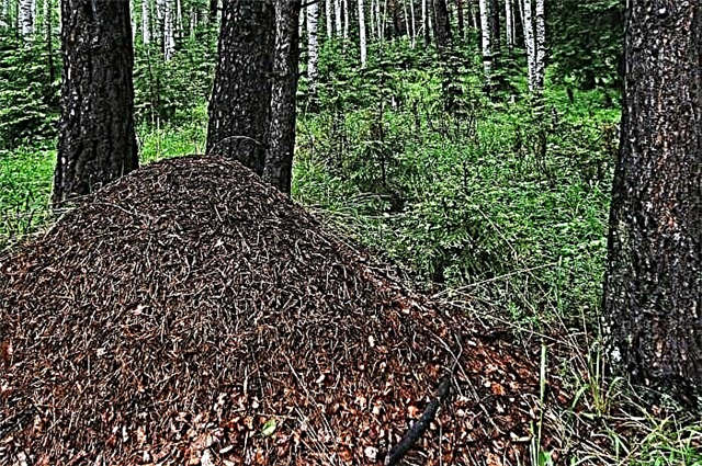
Birch-ant grove
The natural monument is located near the village of Ploskoye in the Yemelyanovsky district and is a birch grove. Its peculiarity is the unique concentration of anthills. An area of almost 10 hectares is covered with ant dwellings. Ant houses are located in the forest with a density of about 100 per 1 ha. In total, there are about 1000 anthills in the grove. The largest of them reach 2 meters in height and almost the same in diameter.
Lugavsky Bor
The natural monument "Lugavsky Bor" was founded in 1991. The main goal is to preserve tape pine forests in the Minusinsk Basin. Forests arose here on the sand dunes in the 19th century. Located 5 km from the village of Kolmakovo. The boron area is 1990 hectares. People come here for walks in a unique and beautiful forest with clean air. It is believed that such walking has a healing effect on the body.

The upper reaches of the first Belaya river
Botanical natural monument. Fir and cedar forest with unique herbs, shrubs, trees, including ancient plants. Some plants were still growing in the preglacial period. The upper reaches of the first Belaya river are still being investigated by scientists, while they often find plants previously unknown to science. Some of the wild plants and mushrooms of this area are included in the Red Book of the Krasnoyarsk Territory.
Sliznevsky failure
It appeared as a result of a landslide in 1946. He almost completely covered a small gorge and a stream in the valley of the Malaya Sliznevka River. At present, the sinkhole is a rocky landslide, which is partially overgrown with dense bushes. There are large boulders and blocks of stone, as well as torn tree trunks. The geological natural monument has been little studied due to the difficulty of access to it and the need for special equipment.

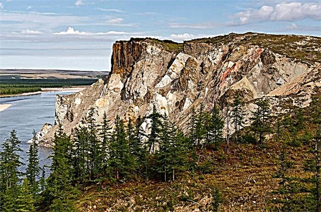
Geological outcrops Variegated rocks
Formed as a result of the fall of a large asteroid about 36 million years ago. After melting as a result of the impact, unique geological rocks - zyuvites and tagamites - came to the surface. The crater is located in the east of Taimyr and is one of the largest in the world, and therefore, it is not only a natural monument of regional significance, but also a national treasure of Russia. It is difficult for tourists to get there on their own.
Spring in the Akademgorodok area
The name “Monastic Key” is popular among local residents. It was declared a natural monument in 1984 in order to preserve a source of clean drinking water. A staircase was built to the spring. However, at present, the territory around the spring is not being improved. The stone staircase has partially collapsed. The territory is littered, despite the efforts of schoolchildren and local residents, who organize volunteer clean-up days.

Dendrological garden in the area of Old Skete
The founders of the arboretum were the monks of the Znamensky male skete. They planted rare plant species, unusual for the Siberian land, near the skete. The skete was abandoned, but the planting of ornamental plants was continued by the students of the Krasnoyarsk Forestry College. Now the garden covers an area of 1.3 hectares. With the help of young naturalists and students, the park was cleared of debris, and ecological paths were laid along it.

Stone town
Located between the rivers Bolshaya Oya and Malaya Oya in the territory of a large natural park Ergaki. The stone town is popularly known as "Ergaki in miniature". It represents bizarre granite rocks up to 40 meters high. A walking path leads to them, but it is recommended to walk along it together with an experienced guide, because there is a chance of getting lost in the forest. The length of the trail is approximately 8 km.

Red stones
The natural monument is located near the town of Talnakh on Taimyr. It is a mountain gorge with a reddish-brown sediment. Two mountains, 578 and 615 m high, form a horseshoe, in the cracks and ledges of which you can observe the remains of marine sediments and volcanic rocks. Climbers and extreme lovers come here. Thanks to the waterfall falling into a small lake, the landscape of the gorge takes on a picturesque look. Not far from the "Krasnye Kamni" there is a ski slope on Mount Otdelnaya, which attracts winter sports enthusiasts.

The second spring on the Uzhurka river
Resting place and source of drinking water. Located at the entrance to the city of Uzhur. The territory of the natural monument covers an area of 150 meters around the spring. This is necessary to protect the drinking water of the spring from microbial and chemical contamination. The crystal-clear water of the spring is considered curative. The spring is popular with locals and tourists. Also, newlyweds often come here for a photo session. They call it "The Spring of Happiness".