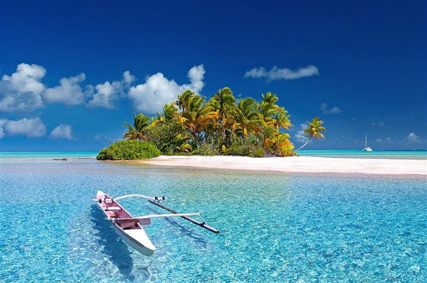
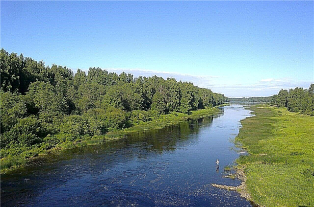
The Leningrad region is rich in natural reservoirs. The extensive river network originates from numerous swamps, lakes and streams. The largest rivers are the Neva, Syas, Volkhov, Svir. The longest river is the Luga, the largest flow rate is in the Neva. Due to the abundance of waterways, the region has developed shipping and hydropower.
Large river arteries, in fact, are natural channels between Ilmen, Ladoga, Lake Onega and the Gulf of Finland. The region's rivers flow mainly in the zone of coniferous and mixed forests, among picturesque landscapes. Since November, all rivers are completely covered with ice, the spring flood brings a strong rise in the level of rivers, and the rise is also possible in the fall against the backdrop of heavy rains.
The longest rivers of the Leningrad region
List of the region's largest waterways.
Meadows
The name of the river is of Estonian or Finnish origin. It flows in the Novgorod and Leningrad regions, has a length of 353 km, originates in the Tesovo-Netylsky swamp and, dividing into two channels, flows into the Luga Bay of the Gulf of Finland. The river is part of the drainage system of the wetland, the floodplain has many bays and oxbows. Due to the presence of rapids, the river is attractive for rafting. On the river are the cities of Kingisepp and Luga.
The length of the river is 353 km, in the Leningrad region - 260 km.

Oyat
The left tributary of the Svir River originates on the Vepsovskaya Upland, flows through the territory of the Leningrad and Vologda regions. The river flows through the hills covered with dense forests. The channel is winding, there are sections with difficult rapids. There are many ancient settlements on the banks, in the village of Alekhovshchina there is a church of the 18th century, and in the village of Bor - the estate of V.D. Polenov.
The total length of the river is 266 km.

Syas
It begins in the swamps of the Novgorod region, but the main part of the basin is located in the Leningrad region. The channel is winding, there is a 5-km rapids section - the Kostrinsky rapids. Syas is connected to the Volga basin. Due to the deposits of iron, the water has a reddish-brown color. The largest city, Syasstroy, is located at the mouth; the oldest pulp and paper mill in the country operates here.
The length of the river is 260 km, in the Leningrad region - 190 km.

Pasha
A large tributary of the Svir River, originates on the Vepsovskaya Upland, from Pashozero. The pool is located in a swampy taiga area, has many lakes, part of it is located on the territory of the Vepsian forest natural park. At the confluence with Syaznega, ancient burial places of local tribes have been preserved. There are many settlements on the shores. The river is navigable, water tourism and fishing are developed.
The length of the river is 242 km.

Swir
It flows along the border of the Leningrad region and Karelia, flows from Onega to Lake Ladoga. The width varies from 100 meters to 12 km. The widest point is in the Ivinsky spill formed by the Verkhne-Svirskaya hydroelectric power station. It is a transport route between Ladoga and Lake Onega. There are tourist routes through ancient villages, the Nizhne-Svirsky nature reserve.
The length of the river is 224 km.

Volkhov
It connects Ilmen with Lake Ladoga. In the middle of the 20th century, a hydroelectric power station was built on the river, which gave rise to the city of Volkhov. In the past, the river was part of the route "from the Varangians to the Greeks." At present, navigation is carried out along the entire length, the Novoladozhsky Canal, which connects the river with the Neva, is open for ships. The current is rather slow, the depth reaches 10 - 12 meters, and the width is 200 - 300 meters.
The length of the river is 224 km, in the Leningrad region - 96 km.

Oredezh
The source of the river belongs to the natural monument “Dontso Tract”. The navigable part is located only in the lower course, before the confluence with the Luga. An interesting feature is the red sandstones of the Devonian period, located on the banks. Ancient fossils and remains of settlements are also found on the territory of the basin. The river is attractive for lovers of boating and fishing; there are many health resorts and recreation centers on the banks.
The length of the river is 192 km.

Lid
The left tributary of the Chagodoshcha flows out of Lake Pelushskoye on the border of the Leningrad and Vologda regions. It flows among dense forests, the channel is sandy, with rocky rifts, the path of the river passes through several lakes. Popular with lovers of water recreation and fishing. The route through Lid is interesting for tourists for its beautiful varied landscapes, as well as for exploring abandoned dams.
The total length of the river is 146 km.

Tikhvinka
The beginning of the river is Lake Eglino on the Valdai Upland. It flows into Syas. The river was part of the Tikhvin water system connecting the Volga and the Baltic, which is currently not functioning. The channel has high rocky banks, rapids, in places it is cut by ravines. The largest city on this river is Tikhvin, the regional center of the Leningrad Region, where the Tikhvin Monastery is located.
The length of the river is 144 km.

Tigoda
The river originates near the Tushinsky moss bog and flows into the Volkhov in the Novgorod region. On the territory of Leningradskaya it passes through the territory of Tosno, Chudovsky and Kirishsky districts. The area is predominantly low-lying, covered with mixed forests, and swampy in places. Used for both rafting and fishing. There is a hunting and fishing base at the mouth.
The total length of the river is 143 km.

Vuoksa
It originates in Finland, from Lake Saimaa. It flows into Lake Ladoga. It is a complex system of lakes and channels, it is fed by about 500 small tributaries, in the upper part of the river there is a powerful current, with rapids and waterfalls. There are 4 hydroelectric power plants operating on Vuoksa on the territory of both states. The river fauna is represented by various species of fish, including valuable ones (whitefish, salmon, trout). On the banks of the river are the cities of Svetogorsk, Priozersk and Kamennogorsk.
The total length of the river is 143 km.

Tosna
The left tributary of the Neva, the source is located near the Oredezh River. It flows into the Neva near the town of Otradnoye. The floodplain of the river is slightly hilly, covered with mixed forests, rich in both forest fauna and a variety of fish in the river. Interesting sights - Sablinskie caves, the Stroganovs' estate in the village of Maryino. Tosna is attractive for fans of kayaking.
The total length of the river is 121 km.

Kapsha
It originates from Kapshozero and flows into the Pasha River. The river flows in the southern taiga zone, the forests are predominantly coniferous, the banks are hilly. The current is fast, with rapids and rifts, the channel is sandy, there are boulders and pebbles. On the section Rebovichi - Ust Kapsha, canoeists are rafting, in the vicinity you can hunt and pick mushrooms and berries. The banks are quite densely populated, the river is floated down the river.
The length of the river is 115 km.

Mga
One of the small tributaries of the Neva. It is famous for the fact that the front line ran along the coast during the Second World War. Remains of defensive fortifications have survived to this day; a German burial is located near Sologubovka. Water tourism on the river is carried out in spring, during the flood period. The width in the upper reaches is no more than 6 meters, in the lower reaches - up to 30 meters, the depth is shallow, 1 - 2 meters. Due to the deposits of peat, the water is colored dark brown. Rich ichthyofauna.
The length of the river is 93 km.

Long
The left tributary of the Luga, originates from Lake Kolpino in the form of an unnamed stream, a full-fledged river comes out of Lake Spass-Kotorskoe. The river flows through the large lake Dolgoe, where rainbow trout are bred. Downstream, the remains of the Holy Dormition Skete and the crypt cave, inside it a consecrated stream. The area is very picturesque: gently sloping shores give way to steep ones, with patches of red sandstone, at the mouth there are many rapids and rapids.
The length of the river is 91 km.

Okhta
A large tributary of the Neva, flows into it in St. Petersburg, 12.5 km from the Gulf of Finland.The river is 90 km long and 10-50 meters wide. The sources are streams on the slope of the Northern Upland. High steep banks, wetlands in places. The Okhta dam was built 9 km above the river mouth, which formed the Okhta reservoir 5.5 km long. The water in the river is highly polluted due to the large amount of industrial wastewater.
The total length of the river is 90 km.

Saba
The left tributary of the Luga, flows into it 102 km from the Luga Bay. The upper part passes through a swampy plain, lower - among hills with coniferous forest, in places it flows through flooded meadows and becomes flooded. There are two high rapids in front of the mouth. The river is home to pike and trout. There are about 20 small villages along the coast.
The length of the river is 90 km.

Lizard
Right tributary of the Luga. Presumably, the river got its name due to the winding channel. The places are very picturesque: steep banks among dense forests, huge boulders, rocky cliffs, deposits of Devonian sandstone. There are caves formed by springs. The artist Ivan Shishkin lived and worked in these places. The water is clean enough, fish are caught.
The length of the river is 78 km.

Izhora
It originates from springs on the Izhora Upland and flows into the Neva along the left bank. All along the river is fed by more than 200 tributaries. The upper part of Izhora is part of the natural monument "Repuzi". Old quarries are located here, many rare plants are protected. Interesting places are located near the village of Pudost. The coast here is formed by a rare Pudost stone, which changes color under different lighting conditions. The water is heavily polluted by sewage.
The total length of the river is 76 km.

Neva
It originates from Lake Ladoga, flows along the Neva lowland and flows into the Neva Bay of the Gulf of Finland. The length of the river is small, but its sufficient width from 210 to 1210 meters and a depth of 8 - 10 meters make it navigable all the way. The most famous islands are located in the Neva delta, 42 of which are located in St. Petersburg. The water in the river is cold and the current is very fast. Several species of fish are found here, including the famous smelt.
The total length of the river is 74 km.

Sister
The river begins from swamps on the upland of the Karelian Isthmus and flows into the Sestroretsk flood, which is connected to the Gulf of Finland. The river bed is meandering, the depth is shallow, rapids are often found. The largest cluster of summer cottages and cottage settlements in the vicinity of St. Petersburg is located on the banks. The area is covered with coniferous forests, many springs come out on the slopes of the river.
The total length of the river is 74 km.

Sista
It originates from Lake Korostovitskoye on the Izhora Upland. It flows into the Gulf of Finland. The banks are steep, overgrown with mixed forest. The river is attractive for fishing enthusiasts. The current is quite intense, the water has a cloudy hue due to limestone deposits. However, the water quality makes it possible to supply the whole city - Sosnovy Bor.
The length of the river is 64 km.

Vruda
One of the tributaries of the Luga flows into it along the right bank. The river is known among lovers of outdoor recreation and fishing for its picturesque banks and clear water. On the gentle banks, overgrown with mixed forest, there are tourist bases, you can pitch a tent in one of the camps. Fish are well caught in numerous quiet backwaters and in shallow waters.
The length of the river is 60 km.

Avloga
A shallow river in the Vsevolozhsky district of the Leningrad region, on the Karelian isthmus. It begins at the village of Hittolovo from the system of lakes and flows into Lake Ladoga. The main part of its length Avloga flows along the bottom of a deep ravine, not reaching 4 km before Ladoga comes out of it. The channel is slightly tortuous; it changes its direction at three major bends.
The length of the river is 54 km.

Wolf
The right tributary of the Vuoksa River flows through the territory of the Karelian Isthmus. It starts at its highest point - from the Lembolov heights. The lower reaches of the river are especially picturesque. The shores are poorly populated. The water is clean, but has a brown tint due to the deposits of peat, the channel is winding, with rifts and stones. The river is suitable for rafting, fishing, people come here to the recreation centers.
The length of the river is 50 km.

Cobona
The river begins in the swamps of the Volkhovsky district of the Leningrad region and flows into Ladoga. The famous Road of Life once started at the mouth of the river. On the bank of the Staroladozhsky Canal, which is crossed by the river, there is a museum "Kobona: The Road of Life". He talks about the blockade years and the feat of the people who worked here.
The length of the river is 45 km.

Loach
A tributary of the Burnaya River, which in turn flows into the Vuoksa. It flows mainly to the north. The river got its name for a very winding channel, with many rifts and obstacles. It is because of the poet that not only fishermen come here, but also lovers of river rafting. In the village of Zaporozhskoe, Vyun is blocked by a dam.
The length of the river is 44 km.

Nazia
The name in the language of the peoples living here means "wolfberry", the banks of the river were covered with this shrub. It flows from the Maluksinsky swamps into Lake Ladoga. Almost the entire length of the river is located on the territory of the Kirovsky district of the Leningrad region. It has high steep banks; beavers are found in the river. A popular route among fans of kayaking.
The length of the river is 42 km.

Volochaevka
It originates from swampy forests near the village of Kirovskoye and flows into Pravdinskoye Lake. All along the way, the river is fed by small rivers and streams. The main part of the channel winds through dense coniferous forests. In the area of the village of Chernavskoe there is a popular place for tourists, where the river cuts through high sandy ridges and runs in the forest along a rocky channel. People come here to relax in silence, pick berries and mushrooms.
The length of the river is 39 km.

Kovashi
Formed by the confluence of the Lopukhinka and the Black River, it flows into the Gulf of Finland near the town of Sosnovy Bor. On the way of the current one can come across rifts, single large stones, many snags and fallen trees. Kovashi is a continuation of the water route, popular among lovers of rafting, starting from the Chernaya River. The entire route, together with Cherna, is 72 km.
The length of the river is 38 km.